Alaska Fish & Wildlife News
October 2016
Unalakleet to Bethel:
A Journey through Coastal Southwest Alaska
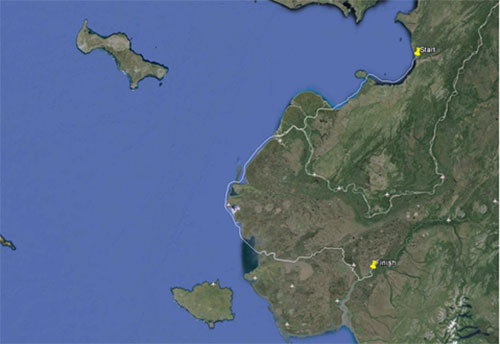
“You’re doing what?!?” was the reply I oftentimes heard from folks when discussing our plan to drive a 22-foot skiff hundreds of miles, from Unalakleet to Bethel. As crazy as it sounded to some people (including myself), I knew that an opportunity like this would be very difficult for me to pass up.
Following the Bering Sea coastline of Southwest Alaska, traversing the entire Yukon River Delta, and navigating our way through a complex network of freshwater lakes, rivers and sloughs, to eventually end up in Bethel would be an adventure to say the least. It certainly would be a great deal of water to cover, and we could see belugas, humpback whales, seals, porpoises, moose, reindeer, muskoxen and countless seabirds. We’d encounter very welcoming and generous people familiar with the land and water, whose help would be invaluable. I began researching and planning for the trip months in advance, and had what I considered to be a pretty solid plan. But you know what they say about the best laid plans of mice and men. Nevertheless, we had to start somewhere.
Our division was in need of a boat to use during our in-season salmon monitoring projects on the Kuskokwim River. Early last winter, the Northern Region Subsistence Division acquired the 22’ heavy gauge aluminum skiff from the Commercial Fisheries Division; the boat had been used in Nome and Unalakleet. This newly acquired vessel seemed like a sound replacement, and especially suitable for the big water of the lower river. We essentially had three options available to us in regards to getting the boat from Unalakleet to Bethel. The first option was to have the boat barged to Bethel. However, barging the boat would have set us behind schedule thereby interfering with our duties; the boat would have to be loaded onto a returning southbound barge, which would have meant that it would not become available to us until mid to late summer. We needed the boat in Bethel prior to the scheduled June 12th subsistence salmon opener. The second option included shipping the boat via airfreight, but the cost exceeded our budget. The third option had Jeff, Dave and I pilot the boat from Unalakleet down to Bethel.
I flew into Unalakleet on the afternoon of May 22nd 2016 with Subsistence Resource Specialist Jeff Park. We found the boat parked in front of the ADFG bunkhouse atop several pallets and 55 gallon drums. We hit the ground running and began working on the boat. Our work included swapping out an older model V6 Evinrude long shaft outboard (which I’m convinced was the heaviest outboard Evinrude ever produced) with a newer 115hp Yamaha four-stroke short shaft outboard. Within a few hours, we had the old engine removed, the transom cut down, and the new outboard installed, controls and all. Next was the fuel system, electronics, and getting it off of the barrels and onto a trailer.
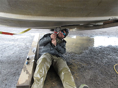
On May 24th the third member of our crew, Subsistence Resource Specialist Dave Runfola flew into Unalakleet and shortly thereafter we had the boat in the water for a test drive. That evening amidst overcast skies and light winds we departed Unalakleet and headed towards St. Michael, our destination being Apoon Pass near Kotlik approximately 150mi to the southwest. As it happened, we began taking on a considerable amount of water two hours after leaving Unalakleet. With the bilge running, it was full throttle to St. Michael. We reached the black sand beach at St. Michael around 11:30pm, secured the boat, and decided to take a walk to see if we could get some help getting the boat out of the water so that we could inspect the hull. In less than one hour after we beached, there were a half-dozen St. Michael residents and a front end loader down at the boat. As the front end loader lifted the boat out of the water, the hull crack was as plain as day as water dripped out from the crack and onto the beach. We placed the boat on rollers on the beach and called it a night. While inspecting the hull the following morning, we discovered two more cracks along the keel, up near the bow. After cleaning the affected areas, I patched the cracks, tarped off the boat, and ran a space heater in an attempt to create more suitable conditions for patch curing; the temperature was in the 40s and it was raining for the entire day, which was really prolonging the curing time.
Repairs at St. Michael
The following morning we left just before the high tide, and traveled through St. Michael Canal, which put us back in the Bering Sea several miles below Stebbins. Along the way, we watched two reindeer cows, each with a calf in tow, trot along the banks and then turn inland with noses high in the air. Our plan was to reach Scammon Bay that day, approximately 230mi to the south. Going around the Yukon Delta, via the open ocean, would’ve required us to travel a long ways out into the Bering Sea in order to avoid sandbars and mudflats and otherwise shallow water, which can extend many miles beyond the mouth. So we decided to use Apoon Pass near Kotlik which eventually put us out near Emmonak. After a brief battle with a sandbar near Alakanuk, we continued on and stopped at Nunam Iqua.
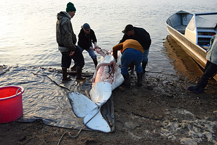
Not being exactly certain of the location of the channel(s) which leads to the ocean, Dave contacted his brother-in-law, a resident of Nunam Iqua, who agreed to guide us out through the pass, and further south to a point several miles above the mouth of Black River. After parting ways, we moved on towards Scammon Bay. Just as Cape Romanzof became visible in the distance, a pod of belugas swam by, several yards off the port side. We reached Scammon Bay late that night, and were all pretty wore out. But there was still work to do - namely, arrange to get the boat welded. After speaking with some folks on the beach who were butchering a freshly caught beluga, the plan was to get the cracks welded up the following morning. We pitched camp on the beach that night to get some much needed rest.
Scammon Bay
The following morning, we began coordinating with some folks at Coastal Villages Regional Fund, the local Community Development Quota Corporation in Scammon Bay. Fortunately, the welding machine could be trailered down to the boat, which was convenient because we had no way of getting the boat over to the shop. Meanwhile, we emptied the boat of all gear and gas, picked up some supplies, purchased more gas, reviewed our route for the following day, and tied up all loose ends. The welder, also a brother-in-law of Dave’s, completed the repairs that afternoon. Afterwards, we packed everything back up into the boat in preparation for the following day’s departure.
The next morning, we did a last minute check to see that everything was in place, added a quart of oil to the outboard, and within a half hour were underway, rounding Cape Romanzof in calm seas on a gorgeous day.
The stretch of water between Scammon Bay and Toksook Bay was relatively easy to navigate, but we did encounter some areas that required us to travel further off of the coast to avoid shallow water (a common theme throughout the entire trip). After a few hours we could begin to see Nelson and Nunivak Islands. Approaching Nelson Island, two clouds of mist shot up from the sea, not more than 25yds off the bow, as we caught a brief glimpse of two very large black blowholes. And the tiny black specks I had noticed along a ridgeline finally came into better view - muskox.
Working for the division I’ve been fortunate to see a great deal of the state; places I would otherwise probably never get the chance to visit. With having said that, Nelson Island was definitely one of the more beautiful places I’ve seen, and was certainly a highlight of the trip.
After rounding the far western shoreline of Nelson Island we eventually pulled into Toksook Bay that afternoon to gas up and take a break. While researching the route during the early pre-planning stages, our original plan was to use the Takslesluk-Kayigyalik Lake system. Included in this route was the Tevyar’aq portage, which essentially connects Baird Inlet to the Kuskokwim River. The portage has been used for many years, and is a tried and true route for people seeking access to the lake system, or Baird Inlet and the coast. In describing the historical use of the lake system, a 2013 Department of Natural Resources report said the following: “The knowledge and skill needed to navigate the tortuous water routes of the lowland tundra of the Yukon-Kuskokwim Delta kept most non-natives from traveling into the area.”[1] So naturally, we took that description as a challenge, and began researching the route to get through the lakes and portage to Johnson River, and eventually the Kuskokwim.
The only problem we faced was the size of the boat. Would we be able to get a 22’ heavy gauge aluminum boat hauling about 800 pounds of outboard, up the ramp, onto the tram car, across the 450’ of rails, and offload it into a lake inlet? Even emptied of all gear and gas, we were talking about moving over a ton of weight (literally). After much deliberation during our planning stages, we all agreed that we might be biting off more than we could chew and that going around and up through Kuskokwim Bay may be more practical. However, we never completely ruled out the portage, and it remained an option for us, even as we beached at Toksook Bay. During our stop at Toksook Bay, we spoke with an elder who inquired about our trip and destination. The elder explained that he rarely traveled around and up through Kuskokwim Bay. He went on to tell us that he has traveled the lake system and crossed the portage dozens of times. And that he believed we could make it through despite the size of our boat, and mentioned that he had taken 22’ boats across the tram in the past. That was all the reassurance we needed!
In order to access Baird Inlet, we needed to reach the Ninglick River above Tununak, which meant that we had to travel back in the direction we came, around the western edge of Nelson Island, and northeast of Tununak. As we approached Tununak we encountered some dense fog and rough weather and were forced to beach the boat and wait it out until the next high tide on the following evening. The following day we spent some time reviewing the lake system route, getting supplies, and adding waypoints into the gps. At 5:30pm that evening we departed Tununak for the Ninglick River.
The weather improved the closer we got to the mouth of Ninglick River, and the sun was shining once again as we neared Baird Inlet. Newtok came into view shortly thereafter, as did the vast watery maze that would be our “highway” to the portage.
The portage
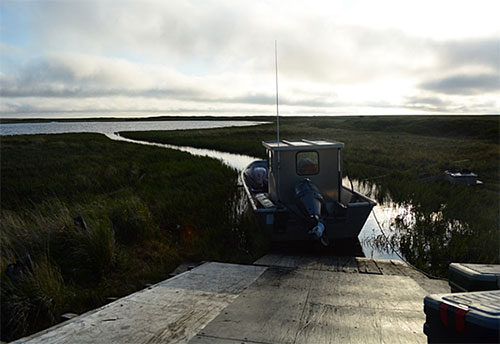
Unfortunately, once we reached Newtok, Dave had to return to Fairbanks, but Jeff and I continued on. Not too long after we entered the first of a series of small rivers which connect lakes to sloughs to creeks, and everything in between, I took a wrong turn, and within seconds we were stuck in some serious mud. Jeff and I worked tirelessly to push the boat back into deeper water. Exhausted, we sat and began to weigh our options. Was this how the remainder of the trip was going to be? Should we return to Newtok and try the Kuskokwim Bay route, or call it quits? The thought of having to turn back did not settle well with either of us; we had come a long way. As we pondered our options, Jeff continued to pore over our maps. “Did you see another turn off back there?” Jeff asked. “I don’t think so,” I replied. “Maybe we should take another look,” suggested Jeff. I’m glad that we did. Before too long we were back on track, zipping through rivers, lakes, and sloughs at 30 mph. The sun faded, and we began to contemplate whether or not we should pitch camp and sleep for a couple of hours. As we rounded a corner near a fish camp, we came across a family who were hanging pike to dry on the rack. It was around 1 am and the first question out of the woman’s mouth was, “How’d you guys get back here?!?” Jeff and I took that as a compliment. The family assured us that getting the boat across the portage wouldn’t be an issue. Those were some really encouraging words. We said our goodbyes, and in just over an hour, we were pulling up to the Tevyar’aq portage ramp; it was 2:15am.
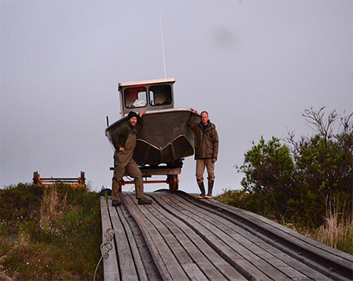
After assessing the situation, we began offloading all of our gear and gas out of the boat and onto the tram car. Jeff and I then pushed the tram car to the opposite side, offloaded the gear and gas, and turned around and went back for the boat. After repositioning the boat, centering it in front of the ramp, we hooked the cable to the bow and began cranking it up the ramp. We took turns, with one person cranking and the other person standing near the boat making sure to keep it centered on the ramp. Jeff and I then placed cribbing along the sides of the tram car to prevent the boat from rocking side to side. We also placed cribbing across the tram car deck in order to maintain the same height as the ramp on the opposite end. After chocking the tram car wheels, we slowly cranked the boat up and over the ramp onto the tram car. Next, we hooked the cable up to the car itself and began cranking the load towards the opposite end.
Upon reaching the other end, we started the process of getting the boat off of the car, onto the ramp, and down into the water. There’s a deadman provided at the opposite end of the portage to be used for getting boats off of the car and down the ramp. It consists of a large square of concrete, maybe 24”wide by 24” long and 12”deep, with a steel pipe sunk in the middle. The idea is to pull the cable from the winch, around the pipe and back up to the boat. Unfortunately for us the deadman just wasn’t enough weight; as we cranked the block would lift up off the ground and the boat wouldn’t budge. So Jeff and I began cribbing up the boat even more than we had, one side at a time, which helped us to raise it up, and inch the boat forward. When we deemed that the bow was far enough over the ramp, we added some weight to the bow. Lastly, we hooked up the two come-alongs, one end to the bow, and using a short length of chain to wedge into a gap in the planks at the bottom of the ramp, I hooked up the other come-along to the chain, hoping that it would hold. After inching it forward little by little, I gave it one last crank and jumped out of the way as it shot down the ramp in a hurry, and then into the water. That was a really good feeling. I asked Jeff what the time was and he replied, “7:30 am.”
While Jeff laid down for a quick nap, I cleaned out and loaded up the boat, strapped down all of our gear and gas, and returned that tram cart to the other side knowing that the family we met the night before would need the car on that end.
For the next several hours, Jeff and I navigated a series of lakes and very narrow inlets and outlets, all of which required us to get out into the water push and drag the boat through, and on into the next lake. We reached Kasigluk in the early afternoon, took a quick breather, and took off down the Johnson River towards the Kuskokwim.
Jeff and I pulled into the Bethel boat harbor at 5 pm on 5/30/16, after having completed one heck of a journey.
After all was said and done, we traveled close to 900 miles, burned through over 200 gallons of gas, and visited nine villages. We saw belugas, humpback whales, seals, porpoises, muskoxen, moose, reindeer, and countless seabirds. Beyond the scenery and sheer adventure, what was most overwhelming was the kindness and hospitality we received in each of the villages we visited. Everywhere we went, people came to greet us, share their knowledge, and help out any way that they could. With having said that, I’d like to send my most sincere gratitude to all of the folks in Unalakleet, St. Michael, Nunam Iqua, Scammon Bay, Toksook Bay, Tununak, Newtok, Kasigluk and Bethel, who lent us a hand and welcomed us into their villages. We’d also like to thank Joe Asuluk of Toksook Bay, for helping us with the lake system route.
Chris McDevitt is a Fish & Wildlife Technician with the Northern Region Subsistence Division, and a former YK Delta resident. He has worked in dozens of villages throughout rural Alaska, and is also a part of the in-season lower and middle Kuskokwim River salmon management project team. Thanks to Jeff Sanders and Robert Sundown of Bethel for providing me with some invaluable info while researching the portage route, early on.
[1] Takslesluk-Kayigyalik Lake System HUC 30502, Zone 4, Kuskokwim River Region FINAL INTERIM SUMMARY REPORT Prepared by Bryan Taylor, Historian I and Nicole Lantz, Historian I BLM/State Assistance Agreement Program Phase II-B Submission August 27, 2013Office of History and Archaeology Alaska Department of Natural Resources Office, pg. 42
Subscribe to be notified about new issues
Receive a monthly notice about new issues and articles.
