Alaska Fish & Wildlife News
November 2016
Mapping Invasive Tunicates in Sitka Waters
Alaska marine habitats are biologically rich and extremely varied, from shallow coastal waters to deep sea trenches. People depend on the resources provided by our oceans and coasts for survival and well-being. Globally, marine habitats are under threat by habitat destruction, pollution, and climate change- all driving losses in biodiversity. Some argue invasive species are an equal, if not the greater, threat to marine ecosystems.
Why should we worry about introduced species when many of them provide food, recreation, or jobs? The concern is that nonindigenous (non-native) species, intentionally or inadvertently introduced, can occupy a new environment and spread relatively quickly and broadly causing short- and long-term environmental, economic, or human welfare impacts. By changing available habitats and nutrient cycles, or preying upon native species, or by introducing pathogens, invasive species can cause cascading negative impacts in their new environment. Sometimes the impacts are dramatic and rapid, more often they are initially subtle and indirect, though potentially becoming significant if left alone for varied periods of time. One characteristic common among invasive species is their successful expansion and ability to take over large areas.
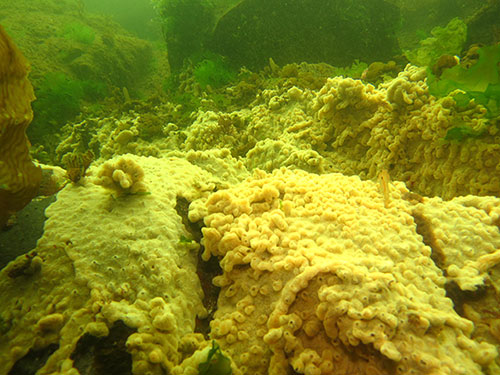
Didemnum vexillum (D. vex) is a nonindigenous colonial tunicate, a type of marine invertebrate that was unintentionally introduced into Whiting Harbor, adjacent to Sitka, Alaska. During World War II, the U.S. Navy took ownership of the islands to the southwest of the Rocky Gutierrez Airport (Sitka airport) and by using bulky riprap to connect several of the islands, the Navy created Whiting Harbor. D. vex is native to Japan waters, and is a common fouling organism at shellfish farms and marinas where it has been introduced. The fast-growing colonial tunicate can cover nets used for growing shellfish. The tunicates restrict water flow and thereby access to planktonic food needed by the developing shellfish stock inside. D. vex can also smother mussels, oysters, and other shellfish within the lantern nets by hampering their ability to open their hinges. Wild Alaska shellfish and other native species that inhabit the seabed are also threatened by the expansive growth of D. vex in Whiting Harbor. In addition to growing over aquaculture gear and shellfish, D. vex can encrust indigenous seaweeds, tube worms, and other invertebrates as well as the rocky, gravelly seabed where they live.
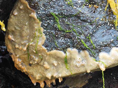
In 2010, the mat-forming invader was found at an aquatic farm in Whiting Harbor. It was already well established on lantern nets used to raise oysters. In addition to growing on the hard surfaces of the aquatic farm and the nets, early dive surveys of Whiting Harbor indicated the invasive tunicate had established on the seabed under the aquatic farm. It even expanded along the seafloor in a patchwork along the intertidal at the head of bay. There were also several discrete infestation sites along the western shoreline. In the past six years, the Alaska Department of Fish and Game and partner organizations have removed the aquatic farm from the water to reduce the chance of the tunicate spreading outside of the bay. They also completed additional SCUBA dive surveys in Whiting Harbor to map the distribution of D.vex and surveyed areas outside of Whiting Harbor thought to have potential to have become infested. The non-native tunicate has not been detected outside of Whiting Harbor. In 2015, Fish and Game, Smithsonian Environmental Research Center and other partners investigated options for eliminating the tunicate from the seafloor.
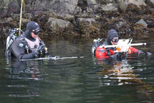
This summer, I accompanied research divers from Fish and Game and the Smithsonian Environmental Research Center who went back to Whiting Harbor to replicate a dive survey that was completed in 2012 to learn about changes in the distribution of the invasive tunicate over the past four years. With transect rods, compasses and plenty of air in their tanks, three teams of SCUBA divers swam transects throughout Whiting Harbor to observe where the tunicate was located in order to delineate the distribution. Most of the divers involved in the survey had previous experience with the D. vex infestation in Whiting Harbor. Their skills and ability to successfully detect and identify the tunicate over the 176 acres of Whiting Harbor would be essential to completing the 94 transects over five days.
Because Whiting Harbor has a deep sandy/muddy basin running through the center that is deeper than 60 feet this area was not covered in this survey. D. vex is not known to establish on sandy or muddy seabed and for this survey, our divers would not be swimming deeper than 60 feet. The deep basin roughly bisected the bay such that transects would originate either on the east or west side of the bay and end when the divers reached the deep basin. The area of the bay nearest to the mouth was covered by seven transects on the east and west sides, for a total of 14 transects at 50 meter intervals or roughly 165 feet apart. The mid-section of the bay had varying transect intervals based on nearness to known infestations of the invasive tunicate.
Based on information from earlier surveys and work in the area over the previous six years, it was known that the main distribution and abundance of D. vex remained at the head of the bay. The mid-section of the bay is where the aquatic farm had been anchored in 2010 when the D. vex was first detected. It also is where several discrete populations occurred along the western shoreline and near intertidal. D. vex had not been detected in the area near the mouth of Whiting Harbor. Because it was impractical to survey the entire seafloor of Whiting Harbor, divers would swim transects at least 50 meters (165 feet) apart to detect D. vex and catalog the percent cover. Each of the three areas of Whiting Harbor (head of the bay, mid-section and near the mouth) had differing concentrations of transects based on the perceived potential to observe D. vex. In other words, areas where D. vex had been detected in the past and areas adjacent to observed infestations had greater concentration of transects than areas where D. vex had not been seen and were far from where known infestation sites occurred. Certainly this effort is a bit like searching for a “needle in a haystack,” so any way to increase the likelihood of finding infestations without surveying the entire bay was implemented.
All transects were approximately two meters, or six feet wide with two divers each collecting data for a one meter, (three foot) swath along the length of each transect. For this type of survey, divers carry a transect rod, which is comprised of two pieces of PVC pipe configured like a cross that is outfitted with a clipboard for datasheets and a compass to stay on bearing. One of the pieces of PVC is one meter (three feet) wide; it acts as a guide to indicate the path over which the diver collects data. While swimming along the seafloor and staying on transect, divers collect information about what they see below them. For each transect they describe the dominant vegetation type present and the dominant substrate type. The size of the rocky substrate on the seafloor is attributed to the substrate type (sand, gravel, boulder, etc.). Most importantly, when D. vex is observed, divers estimate what percentage of a 5 meter by 1 meter (15 feet by three feet) area is covered by tunicates. If that doesn’t sound like enough to keep one busy while swimming around with a heavy tank on one’s back and breathing through a tube, the fact that the survey occurred in June meant that the divers were also swimming through long, billowy blades of kelp for many of the transects. This was not recreational diving.
I am always impressed when I work with the Fish and Game and Smithsonian research divers. Their competency, can-do approach and optimistic attitude ranks high on my list of positive traits. They’re also proficient on-the-fly problem solvers while working in the field, which was a plus during this survey.
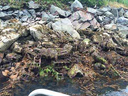
After World War II, Whiting Harbor became a dump for the Navy and then later for the community of Sitka. This is noteworthy because there is seemingly no end to the types and amount of debris one might come across when diving there. The plastic dolls and dog-shaped piggy banks made for laughs for the crew and the old bottles are reminders of bygone times. What makes the fact that our survey area was a dump important is the amount of metal debris visible along the shoreline and hidden below the surface. Remember how I mentioned the divers relied on a compass to designate the direction to travel? In this case, it’s imperative that the compass isn’t misdirected as a result of interference. Old metal jeep frames, huge culvert-like pipes and random rusty junk provide a serious amount of interference.
Although we had experienced this challenge in a previous survey, it wasn’t until we were again met with the problem that we could wrap our heads around a solution. When working in the grid of transects at the head of the bay, we observed that multiple transects were considerably skewed toward the metal junk pile. It became clear we’d need to devise a method to keep divers on target. If not, there would be gaps of area for which we had no data about the absence or presence of the invasive tunicate.
Because department divers work in areas where there may be hazards or danger their support skiff is outfitted with a tool to send a message to divers to return to the surface. The support crew can position themselves near the divers by following their air bubbles rising to the surface of the water. By dangling the “diver alert” device into the water near the bubbles and clanging it around, a loud jingling sound can be heard under the water. When divers veered off transect to the left, this unit was used to instruct divers to adjust their heading by 5° to the right. Banging on the side of the metal support skiff with a hammer was a signal for divers to adjust 5° to the left. When working the transects near the junk pile at the head of the bay, the topside support team basically banged and jingled the divers along on their way to the transect end point. It wasn’t elegant, but it worked really well.
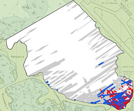
Once all of the transects were completed, and the gear and boats were decontaminated to ensure that we and our gear were not vectors for the spread of D. vex, the data was analyzed by a Division of Sport Fish biometrician (statistician). The biometrician is able to convert the transect data collected by the divers to create a map of the distribution and the percent cover of the D.vex (see map). One key observation during the survey was that the northernmost discrete population of D. vex along the northwest arm of Whiting Harbor was no longer detected. Divers spent a fair amount of time looking for this population; they dropped into the water and searched around GPS coordinates marking known infestation sites. There were no visible signs of the infestation at that site. This was surprising but good news. At this point in time, I’m unable to report why it had “disappeared”.
Finally, the biometrician could review the map of the distribution observed during a survey of Whiting Harbor in 2012 and compare it to the observed distribution in 2016 to devise a map of the change in distribution. The map displaying the distribution change shows that divers observed a change in either presence or percent cover in the blue or red areas. In conclusion, the head of the bay still has a patchy distribution of D. vex on the seabed. The initial analysis indicates the populations of the Didemnum vexillum tunicate in Whiting Harbor is changing. In the coming year, the department will partner with the Smithsonian Environmental Research Center to continue investigating options to eliminate the invasive tunicate from Alaska.
Tammy Davis is the Coordinator of the Invasive Species Program at ADF&G and is based in Juneau.
For more on this project, see Cutting Edge Science on the Seafloor - Testing Biocides on Invasives in Marine Waters
Subscribe to be notified about new issues
Receive a monthly notice about new issues and articles.
